UNH  |   EOS  |   ESRC  |   WSAG     

Global-RIMS

A Water Systems Analysis Group geo-spatial data explorer


UNH


GWSP


NASA


NOAA


AusAID


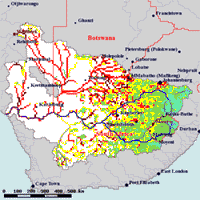
Global Rapid Indicator Mapping System (Global-RIMS)

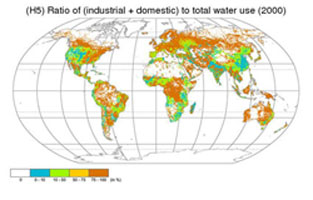
Supporting Water Cycle Science and Water Resource Management

Hydrology is at an important crossroads. As articulated in several "grand challenge" documents, we’ve made great progress in process-level understanding at plot, hillslope, and small catchment scales, but our capacity to pass to the next horizon—to understand inherent variability in the water cycle, predictability, human dimensions, and links to biogeochemical cycling over broader domains—requires a major reformulation of our thinking and a purposeful move toward synthesis and systematic observation.


image 1

Ecohydrology Mapping

image 3

Global Datasets

image 2

Poverty Indicators


We focus here on an emerging view that humans are today embedded into the basic character of the water cycle, through a myriad of processes including water abstraction and flow diversion, land cover change, pollution, destruction of aquatic biodiversity, and climate change. A major scientific challenge is to understand how these changes manifest themselves and if they generate synergistic impacts across the different scales.


Overview
Data Explorer


Home   |   WSAG   |   ESRC   |   EOS   |   UNH   |   Funding Partners   |   Contact Us